
Pawleys Island / Georgetown & Horry Counties, SC
Town told local action is key to historic preservation – Coastal Observer (Coastalobserver)
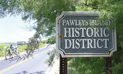
Summary: Pawleys Island is weighing how to protect its historic beach houses, a collection of 19th-century structures and vernacular ‘Pawleys look’ homes that define the island’s character. State preservation officials have told the town that federal grants for property surveys are available, but the real leverage lies in local ordinances. The town is navigating a tension between preserving architectural heritage and respecting property rights, with a current variance request for a 1939 house highlighting the immediate pressure. A key incentive under discussion is a flood regulation exemption that could make renovation financially viable for owners of historic properties.
Why it matters: This local regulatory debate is a microcosm of the coastal South’s struggle to retain place-defining character against the economic pressures of redevelopment, rising sea levels, and generational turnover.
Context: Historic districts on vulnerable barrier islands often face a slow-motion crisis: the cost of elevating structures to meet modern flood codes can make demolition the only rational choice for owners, eroding the very fabric the designation seeks to protect.
"Pawleys Island ## Town told local action is key to historic preservation By Charles Swenson|January 13, 2025 The island’s historic district was placed on the National Register in 1972. Even if the." — COASTALOBSERVER
Commentary: The state’s blunt directive underscores that federal recognition without local teeth is merely ceremonial. The proposed flood regulation exemption is a clever, if narrow, tool that aligns preservation with practical adaptation, making it a test case for other flood-prone historic communities. If Pawleys Island acts, it could create a replicable model for saving vernacular architecture where tourism economics and climate risk intersect.
Date: May 02, 2026 12:00 AM ET
URL: https://coastalobserver.com/town-told-local-action-is-key-to-historic-preservation/
AI Sentiment Score: Negative (87%)
AI Credibility Score: 10.0/10 — High
Scores and text generated by AI analysis of the source article indicated.
Planners ignore calls for delay on wetlands rules – Coastal Observer (Coastalobserver)
Summary: Georgetown County’s Planning Commission voted 5-1 to recommend adoption of a long-debated wetlands protection ordinance, rejecting calls for further delay. The measure mandates a 35-foot buffer for wetlands over half an acre in new development and requires county approval for filling wetlands larger than a quarter acre. It now proceeds to County Council, which must hold another workshop before three formal votes.

Why it matters: This sets a regulatory floor for coastal development that will directly shape future land use, property values, and flood resilience in a region where tourism and real estate are economically dominant.
Context: The ordinance represents a two-year effort to codify protections, reflecting growing pressure to balance development with environmental risk management in low-lying coastal communities.
"The vote followed a joint workshop between the commission and the council at which council members said they wanted to have another workshop on the ordinance that will establish a minimum 35-foot buffer between wetlands that cover more than half an acre in new residential and commercial development." — COASTALOBSERVER
Commentary: The commission’s push against deferral signals impatience with procedural delays on a foundational land-use rule. The specific thresholds—half an acre for buffers, a quarter-acre for fill—create a clear, if modest, compliance boundary for developers. This will test the council’s appetite for imposing costs on new construction in exchange for purported long-term ecosystem and flood-control benefits, a trade-off increasingly central to coastal governance.
Date: April 29, 2026 12:00 AM ET
URL: https://coastalobserver.com/planners-ignore-calls-for-delay-on-wetlands-rules/
AI Sentiment Score: Negative (80%)
AI Credibility Score: 10.0/10 — High
Scores and text generated by AI analysis of the source article indicated.
COASTAL OBSERVER (Coastalobserver)
Summary: Georgetown County’s Planning Commission unanimously rejected a rezoning request that would have allowed 182 apartments on a 14.4-acre site originally purchased for a tech park. The land, on Petigru Drive in Pawleys Island, was intended for commercial development. The commission argued that swapping commercial space for residential units contradicts the county’s future land-use plan. The decision now moves to the County Council for final approval.

Why it matters: This signals a tightening of local land-use policy in a coastal region where the choice between residential density and commercial tax base directly shapes community resilience and economic diversification.
Context: The county bought the land in 2016 for a tech park, reflecting an earlier economic development strategy. The commission’s recent rejection contrasts with its approval last month of 115 multifamily units in Murrells Inlet, highlighting an inconsistent or location-sensitive approach to density.
"Swapping 167,000 square feet of planned commercial development at Pawleys Island for 182 apartments would run counter to the goals of Georgetown County’s future land-use plan, members of the Planning Commission say." — COASTALOBSERVER
Commentary: The commission’s vote prioritizes a theoretical commercial tax base over immediate housing supply, a gamble in a tourist economy where service-worker housing is scarce. It reflects a broader coastal tension: planning for a diversified future economy versus yielding to the pressure for residential development. If upheld by the council, it keeps a prime parcel in limbo, testing the county’s commitment to its own long-term plan against the market’s demand for density.
Date: April 30, 2026 12:00 AM ET
URL: https://coastalobserver.com/0-to-182-units-commission-says-no-5-0/
AI Sentiment Score: Negative (50%)
AI Credibility Score: 10.0/10 — High
Scores and text generated by AI analysis of the source article indicated.
Data center talks plague Horry County government committees (Myrtlebeachonline)
Summary: Horry County is drafting zoning amendments to permit data centers, a first for the coastal jurisdiction. The Infrastructure and Regulation committee is debating location standards, including a proposed 200-foot setback from residential lots, but has delayed a vote pending further research. No formal proposals have been filed, positioning this as a preemptive regulatory move.

Why it matters: Preemptive zoning for data centers signals a shift in coastal land use priorities, balancing economic development against residential character and setting a precedent for other tourism-dependent counties.
Context: South Carolina’s legislature is considering statewide data center regulations, but local governments are moving first to control siting and environmental impacts.
"Horry County could join the growing list of South Carolina counties allowing data centers, but Horry officials want to set clear regulations first. “Our zoning ordinance does not currently include standards specific." — MYRTLEBEACHONLINE
Commentary: Horry County’s cautious, research-driven approach reflects the tension between attracting capital-intensive infrastructure and preserving a tourism-centric landscape. The 200-foot residential buffer is a minimal concession; the real test will be whether regulations address water use, energy demand, and visual impact in a region already strained by seasonal population swings and climate vulnerability.
Date: April 20, 2026 12:00 AM ET
URL: https://www.myrtlebeachonline.com/news/local/article315470713.html
AI Sentiment Score: Negative (80%)
AI Credibility Score: 10.0/10 — High
Scores and text generated by AI analysis of the source article indicated.
Graves Station meeting will focus on stormwater – Who’s On The Move (Whosonthemove)
Summary: Georgetown County and the South Carolina Office of Resilience are holding a public meeting on April 23 for the Graves Station community to provide input on a federally funded stormwater infrastructure project. The design phase, led by engineering firm McCormick Taylor, is underway with substantial completion of construction targeted for late 2027. The funding originates from a U.S. Department of Housing and Urban Development grant allocated after major disasters in 2015, 2016, and 2018.
Why it matters: This meeting represents a tangible, late-stage intervention point for a vulnerable coastal community to shape resilience infrastructure that will directly affect property and safety, testing the efficacy of post-disaster grant implementation.
Context: Georgetown County’s low-lying communities have faced repeated, severe flooding from storms and rainfall events, making stormwater management a persistent and politically charged issue where project timelines often lag behind community needs.
"The project is funded through a U.S. Department of Housing and Urban Development grant allocated to South Carolina following a series of major disasters, including the 2015 floods and hurricanes in 2016 and 2018 that caused severe impacts across Georgetown County." — WHOSONTHEMOVE
Commentary: The timeline—design finalization in fall 2026, construction completion late 2027—illustrates the multi-year bureaucratic pipeline of federal disaster recovery funds, placing this project’s benefits nearly a decade after the triggering 2018 hurricanes. For Graves Station residents, this meeting is a rare formal channel to influence technical designs that will define their flood risk for decades, but the protracted schedule underscores the systemic friction between urgent community need and the pace of state-managed infrastructure delivery.
Date: April 22, 2026 12:00 AM ET
URL: https://whosonthemove.com/graves-station-meeting-will-focus-on-stormwater/
AI Sentiment Score: Negative (71%)
AI Credibility Score: 10.0/10 — High
Scores and text generated by AI analysis of the source article indicated.
Post ID: b3b336ab